Kalypso Simulation Platform: An Open Source Application
The content below is from the site's 2007-2008 archived pages. We at The Code Factory are huge fans of this product and preserved the site so that our interns could continue to reference some of the material. While original intended for simulation of hydraulic models, our team has repurposed the original code base for more generic usage including wind tunnel emulation and fabric stress emulation.

kalypso-Simulation-platform is an open source application for geospatial modeling and simulation. It is primarily developed to be a user friendly tool for GIS-based modeling and simulation of hydrological and hydraulic numerical models. Thanks to a generic approach one can use the platform to handle models of arbitrary nature.
kalypso Enterrise are customized versions of the kalypso-simulation-platform that are deployed for several engineering tasks such as flood forecast systems or decision support for urban planning.
kalypso is a LGL-licensed open source java application. The implementation is based on the Eclipse Rich Client platform (RC)

GNU LESSER GENERAL PUBLIC LICENSE
Version 3, 29 June 2007
Copyright (C) 2007 Free Software Foundation, Inc.
Everyone is permitted to copy and distribute verbatim copies of this license document, but changing it is not allowed.
This version of the GNU Lesser General Public License incorporates the terms and conditions of version 3 of the GNU General Public License, supplemented by the additional permissions listed below.
Information about the kalypso-Simulation-platform are spread over different web-sites of contributing organisations. Please visit one of the following websites:
www.kalypso.wb.tu-harburg.de
News, user-forum, develoer collaboration and source code access (cvs)
hosted at Institute for River and Coastal Engineering, University of Technology Hamburg-Harburg (TUHH), Germany
kalypso.bjoernsen.de
kalypso general informations
hosted at BCE, Koblenz, Germany
kalypso-Twiki
kalypso's Twiki (needs acount)
hosted at BCE, Koblenz, Germany
+++
172 Kalypso is a modeling and simulation platform for GML-based models. It is primarly developed to be a user friendly tool for the simulation of hydrological and hydraulic numerical models. Thanks to Kalypso's underlying generic approaches of the GML implementation, one can use the platform to handle GML models of arbitrary nature.
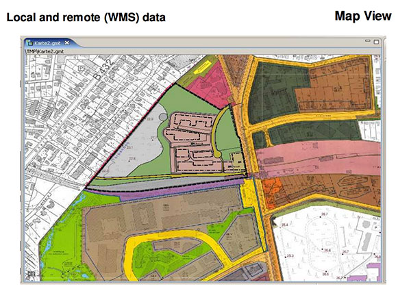
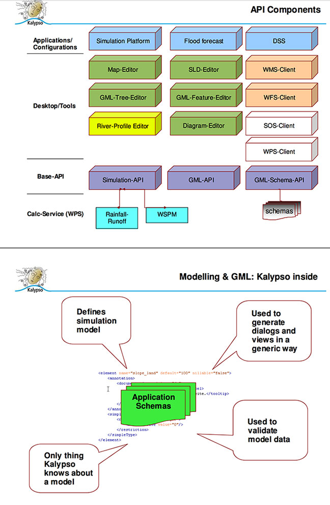
Kalypso consists of a Rich Client application which lets the user visualize and edit GML data in a generic way (both GML 2 and 3 versions are supported) and is also a client for several OGC Webservices (WMS, WFS, SOS). On the other hand, Kalypso brings a set of artifacts for a service oriented architecture in order to support gml processing.
Kalypso parses GML application schemas including depending ones such as the GML base schemas itself into a strong feature- and property-typed system by building on top of standard XML techniques such as SAX and Java API for XML-Binding.
Kalypso is LGPL open source and among others it is based on the Eclipse Platform and deegree. Please see http://www.kalypso.wb.tu-harburg.de. Introduction
-----
Kalypso is a modeling and simulation platform for GML-based models. It is primarly developed to be a user friendly tool for the simulation of hydrological and hydraulic numerical models. Thanks to Kalypso's underlying generic approachs of the GML implementation, one can use the platform to handle GML models of arbitrary nature. Kalypso Rich Client Application
-----
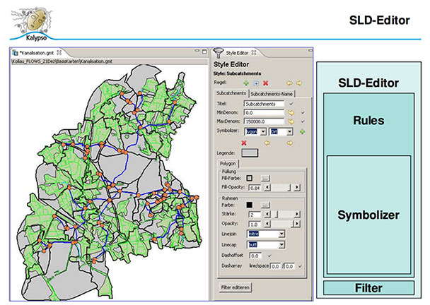
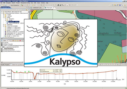
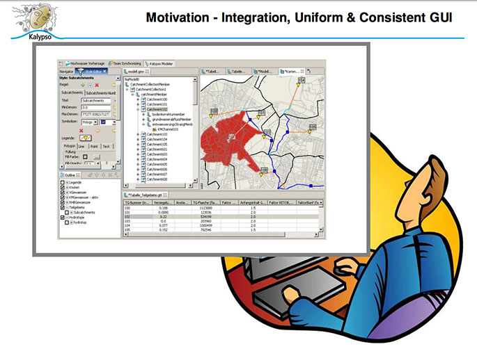
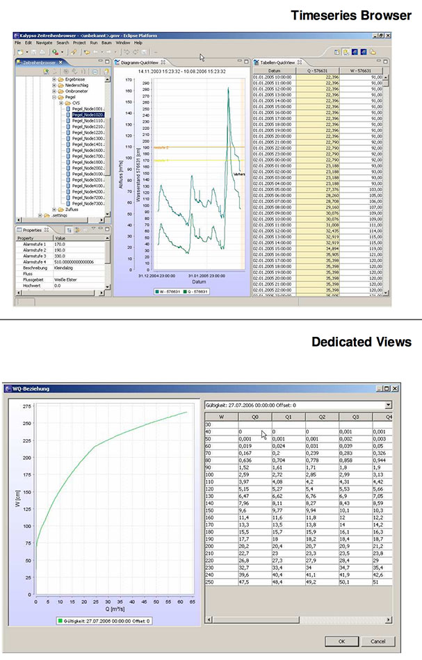
Kalypso consists of a Rich Client application which lets the user visualize and edit GML data in a generic way (both GML 2 and 3 versions are supported). Beneath generic GML views and editors such as a map view, table view and tree view, other views can be registered to Kalypso via a plugin-interface for named feature types. This enables Kalypso for example to support GML-based modeling of river profiles (aka cross-sections) via a registered Observation-profile editor for a river-profile feature.
In order to achieve a strong (feature-)type system, Kalypso parses GML application schemas including depending ones such as the GML base schemas itself into a strong feature- and property-typed system by building on top of standard XML techniques such as SAX and Java API for XML-Binding. Kalypso's schema parser supports a wide range of XML features such as complex types, groups, includes, imports and substitution groups. Higher level GML types such as Observations and Measurements are supported as well in a generic way. At the same time, Kalypso is a client for several OGC WebServices? such as WMS and WFS. The development of an SOS client is being undertaken as well. Kalypso-Services
-----
Kalypso brings a set of artifacts for a service oriented architecture. It consists of server applications whith generic support for gml processing. On top of this infrastructure, special numerical models have been implemented. Legacy modeling applications have been integrated into Kalypso's Model Plugin architecture, suppressing the presence of heterogenous GUI front-ends and distributed installations. Further GML based processes are in construction and an adoption of the OGC Web Processing Service interface is under consideration. Kalypso-API
-----
Kalypso is LGPL open source and among others it is based on the Eclipse Platform and deegree. The sources and a developer portal are available at http://www.kalypso.wb.tu-harburg.de. For a benefit of semantic interoperability we want to encourace developers and model designers to use strong typed GML application schemas and applications. As the sources are structured in a modular way, the source code for GML-processing can be used also separetely from the GUI-part. Kalypso is under active development and currently provides user interfaces for several numerical (hydrological and hydraulic) models for various river basins in Germany.
Furthermore three different Decision Support Systems with a strong accent on ecological information management are based on Kalypso's API. FOSS4G2006 - Free And Open Source Software for Geoinformatics Session 7 : Desktop application Gernot Belger [email protected] Marc Schlienger [email protected] Andreas von Dö[email protected] Gernot Belger [email protected] Marc Schlienger [email protected] Andreas von Dömming [email protected]

More Background On Kalypso-Simulation-Platform.org
Kalypso-Simulation-Platform.org represents the preserved online identity of Kalypso, a major open-source software suite designed for environmental modeling, hydrological simulation, hydraulic analysis, flood forecasting, and geospatial data management. It occupies a meaningful place in the landscape of scientific and engineering tools used across Europe and beyond, especially in river-basin research, water-resource management, and academic studies involving GIS-based simulations.
Although its most active development period occurred between the mid-2000s and early-2010s, Kalypso remains historically significant for being one of the earliest fully open-source, GML-based (Geography Markup Language) modeling environments capable of performing advanced water-related simulations. The preserved versions of the website offer a rare snapshot into a period when universities, public agencies, and engineering firms collaborated to create open, transparent modeling tools for high-stakes environmental planning.
This article offers an in-depth examination of Kalypso-Simulation-Platform.org, including its history, ownership, technological structure, academic background, modules, audience, cultural context, popular uses, and long-term importance.
Origins and Ownership
A Collaboration Between Academic and Engineering Institutions
The Kalypso platform originated through a collaboration between:
-
A prominent German engineering consultancy specializing in environmental, hydrological, and hydraulic modeling.
-
The Institute for River and Coastal Engineering at the Hamburg University of Technology (TUHH), a respected academic institution known for research in water systems, hydromechanics, flood risk, and coastal engineering.
This hybrid academic-industry partnership shaped Kalypso into an environment that was both scientifically rigorous and practically useful. Students, researchers, and professional engineers could all operate within the same toolset, promoting knowledge transfer and real-world applicability.
Open-Source Licensing and Philosophy
Kalypso was released under the GNU Lesser General Public License (LGPL) v3, a license that encourages widespread use and modification while retaining core freedoms for end-users.
This allowed:
-
Universities to teach modeling on the platform without licensing fees.
-
Engineering firms to customize modules for individual river basins.
-
Municipalities to run flood-forecasting systems without proprietary software constraints.
-
Researchers to publish models that others could reproduce.
The open-source nature of Kalypso was critical to its adoption in public-sector environmental projects, where transparency and accountability are essential.
Purpose of Kalypso and the Role of the Simulation Platform
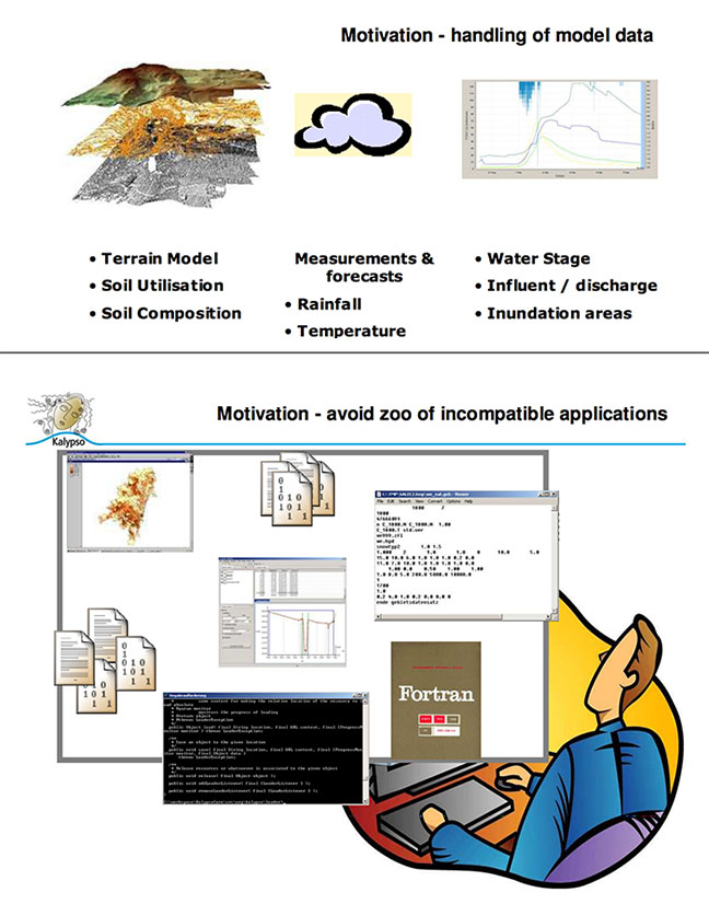
Kalypso was built as a comprehensive modeling and simulation environment for geospatial problems involving water. Its purpose was to create a unified platform capable of:
-
Representing real geographic environments.
-
Ingesting and analyzing large datasets.
-
Running hydrological and hydraulic numerical models.
-
Visualizing results in maps, tables, and charts.
-
Supporting open standards like GML and OGC services.
-
Acting as both a desktop client and a framework for server-based services.
The platform became a foundation for:
-
Flood-management systems
-
Urban-planning decision-support tools
-
River-engineering studies
-
Coastal and watershed modeling projects
-
Academic coursework in geoinformatics and hydraulic engineering
The project’s emphasis on GML-based modeling set it apart early on, as few tools offered native support for structured, strongly-typed geographic data at that time.
Key Features and Technical Architecture
Kalypso’s architecture is composed of several layers working together to support complex geospatial simulations.
Eclipse Rich Client Platform (RCP)
The desktop application was built on the Eclipse RCP framework, which provided:
-
Plugin-based extensibility
-
Stable cross-platform capability in Java
-
Modular design allowing custom views, editors, and simulation engines
This architecture enabled Kalypso to grow as users added specialized tools for unique modeling needs.
GML-Driven Modeling
Kalypso’s most innovative component was its deep reliance on GML, including:
-
Support for GML 2 and GML 3 data structures
-
Parsing of complex application schemas
-
Strong, typed representations of geographic features
-
Support for imports, substitution groups, and schema dependencies
Because of this, Kalypso was able to formalize environmental and engineering data in a way that matched emerging GIS standards.
Integration With OGC Web Services
Kalypso supported:
-
WMS (Web Map Services) for base layers and rendered maps
-
WFS (Web Feature Services) for vector data access
-
SOS (Sensor Observation Services) in development for real-time monitoring
This positioned Kalypso ahead of many contemporaries in adopting open-geospatial interoperability standards.
Plugin-Based Numerical Modeling
Kalypso provided a family of specialized modules for hydrological and hydraulic tasks, including:
-
Rainfall-runoff simulation
-
Surface-water flow modeling
-
Groundwater flow analysis
-
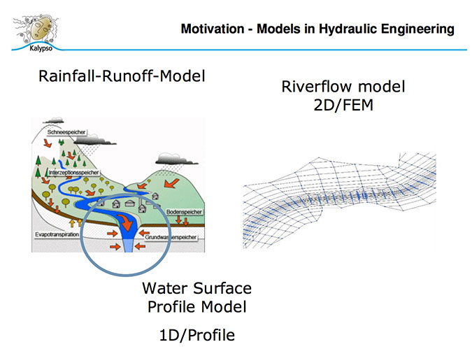
Cross-section and river-profile management
-
2D flood models
-
Decision-support systems combining environmental and socio-economic data
The platform was intentionally modular, so newly developed models could plug into the existing interface.
Major Components of the Simulation Platform
Kalypso Hydrology
This module handles rainfall-runoff processes for catchments and watersheds. It is commonly used for:
-
Flood forecasting
-
Water-resource planning
-
Environmental impact assessments
-
Climate scenario modeling
Kalypso Hydraulics
This component simulates water flow through river networks and floodplains. Engineers rely on it for:
-
Calculating water levels
-
Modeling flood inundation areas
-
Evaluating the impact of river engineering structures
-
Supporting local and regional flood-risk management plans
KalypsoBASE
The core framework includes:
-
Map viewers
-
Table editors
-
Tree-view data management
-
Data import/export utilities
-
GML schema handlers
It serves as the “operating system” for all Kalypso models.
Decision-Support Systems
Kalypso was also used to build ecological and environmental DSS applications, allowing planners to:
-
Compare scenarios
-
Analyze habitat conditions
-
Combine simulation outputs with social and economic datasets
These DSS tools were often implemented for government agencies.
Use Cases and Applications
Kalypso’s software suite has been applied across multiple domains, including:
Flood Forecasting
Kalypso underpins real-time flood-forecasting systems for:
-
River catchments in Germany
-
Small municipalities needing reliable hydrological forecasting
-
Regional water-management authorities
The platform’s modular structure allows it to be tailored to specific basins.
Urban Planning
Cities have used Kalypso for:
-
Stormwater management
-
Evaluating drainage system capacity
-
Modeling the hydrological impact of urban development
River Engineering Projects
Engineers rely on Kalypso for:
-
Cross-section analysis
-
Bridge and weir impact modeling
-
Sediment transport assessments
Environmental Education and Research
Universities across Europe have incorporated Kalypso into:
-
Hydraulic engineering curricula
-
Hydrology labs
-
GIS modeling coursework
-
Master’s and PhD research projects
Its open-source status makes it ideal for teaching scientific reproducibility.
Audience and Popularity
Kalypso attracted a diverse user base:
Academic Researchers
Because of its support for open standards and XML-based modeling, researchers used Kalypso to test new methods for:
-
Water-flow simulation
-
Landscape modeling
-
Data integration techniques
-
Environmental informatics
Consulting Engineers
Engineering firms valued Kalypso because:
-
It reduced licensing costs
-
Its structured GML approach ensured data transparency
-
It integrated well with other GIS tools
-
It supported repeatable, scenario-based studies
Government Agencies
National, regional, and municipal authorities applied the platform in:
-
Flood risk management
-
Watershed management
-
River restoration projects
-
Climate-adaptation planning
Educators and Students
Its open availability made Kalypso a frequent teaching tool in geoscience, hydrology, hydraulic engineering, and geoinformatics.
Geographic Location and Institutional Context
Kalypso’s development was centered in Germany, particularly:
-
Koblenz — home of the engineering firm that co-developed the platform
-
Hamburg-Harburg — location of the TUHH Institute for River and Coastal Engineering
This geographic base positioned Kalypso within a network of German water-resource research, where:
-
Flood-risk management is a national priority
-
Urban planning frequently intersects with hydrology
-
Riverine and coastal flood events require advanced modeling
Its German origins also meant that much early documentation, user forums, and academic publications were produced in collaboration with European research groups.
Press, Media Coverage, and Conferences
Kalypso received attention in several professional contexts during its active years, including:
-
GIS and geoinformatics conferences
-
Open-source geospatial events (e.g., FOSS4G)
-
European hydraulic-engineering congresses
-
Research papers in hydrology and engineering journals
Kalypso was highlighted for:
-
Its early adoption of GML for modeling
-
Its modular architecture
-
Its role in flood-forecasting systems
-
The successful use of its DSS capabilities in environmental projects
While not mainstream software, it maintained a strong reputation within professional geospatial and environmental-modeling circles.
Cultural and Scientific Significance
Kalypso’s importance extends beyond its technical features:
Pioneering Use of GML
Kalypso was among the earliest modeling environments to embrace GML as a core data foundation. This was forward-thinking at a time when many GIS tools relied heavily on proprietary formats.
Open-Source Transparency in Environmental Decision-Making
Flood-management decisions often require public trust. Kalypso enabled:
-
Open access to algorithms
-
Transparent assumptions
-
Reproducible models
This contributed to more democratic and accountable environmental governance.
Educational Impact
Generations of students learned hydraulic and hydrological modeling through Kalypso. Many institutions used it as a teaching platform before proprietary tools became dominant.
Long-Term Preservation of Knowledge
Even though Kalypso’s most active development phase has passed, the preserved site and archived documentation provide a snapshot of:
-
Early open-source GIS evolution
-
The scientific thinking of the period
-
The progression of flood-risk modeling
This makes Kalypso valuable to digital historians of science and technology.
Why Kalypso-Simulation-Platform.org Still Matters Today
Although newer tools exist, Kalypso remains important because it represents:
A case study in open, collaborative engineering
Kalypso showed how academics, industry professionals, and public agencies can work together on software that benefits society.
A model of open geospatial architecture
Its use of XML schema parsing, GML typing, and OGC interoperability influenced later European geospatial systems.
A foundation for successor systems
Some modern environmental modeling frameworks build on the principles Kalypso introduced, especially in modularity, open standards, and transparent computation.
A preserved resource for researchers
The archived website retains:
-
Documentation
-
Technical descriptions
-
Module backgrounds
-
Historical context
Researchers still reference it when examining early GIS-simulation platforms.
Kalypso-Simulation-Platform.org represents far more than a software site—
it is the historical footprint of a major open-source effort in environmental modeling, hydrology, and hydraulic analysis. Built on academic-industry collaboration, leveraging open standards, and designed for transparency and extensibility, Kalypso contributed significantly to water-resource planning, flood management, and environmental decision-support.
Its comprehensive architecture, GML-based modeling, support for OGC services, and extensible simulation tools made it a pioneering platform in the late 2000s and early 2010s. Even as newer technologies have emerged, the preserved Kalypso materials continue to serve as an important educational and historical reference.
Kalypso remains a testament to what is possible when scientific rigor, open-source philosophy, and practical engineering needs converge into a unified modeling system.
![]()